Canada’s Atlantic provinces are bracing for the strongest storm they have experienced on record as Hurricane Fiona barrels through the North Atlantic, set to hit the area Friday night into Saturday.
The storm, which unleashed devastating rains earlier this week in Puerto Rico, is expected to deliver wind gusts over 100 mph in parts of Nova Scotia and generate a dangerous ocean surge, or rise in water above normally dry land.
Ahead of Fiona, the Canadian Hurricane Centre has issued a hurricane watch for portions of Nova Scotia, Prince Edward Island, Iles-de-la-Madeleine and Newfoundland.
“Hurricane Fiona has the potential to be a landmark weather event in Eastern Canada this weekend,” the Centre tweeted.
Fiona is one of five different systems that meteorologists are carefully tracking in the Atlantic, which has roared to life amid the peak of hurricane season.
There’s also Tropical Storm Gaston, which is centered 375 miles west-northwest of the Azores over the northeast Atlantic. The Azores are under tropical storm warnings, and could see conditions deteriorate Friday and remain inclement through late Saturday. In addition, a tropical wave exiting the coast of Senegal in Africa could strengthen into a named storm in the next few days. There is also a disturbance midway between Africa and South America that could gradually develop. Of potentially high concern is another fledgling storm that could deliver a serious blow to the Gulf or Caribbean.
Hurricane Fiona struck Puerto Rico on Sept. 18, leaving residents without power, water and safe shelter. Residents from Ponce and Salinas shared their stories. (Video: Zoeann Murphy, John Farrell, Drea Cornejo/The Washington Post)
Storm developing in the Caribbean could pose danger to the U.S.
Fiona’s approach toward Canada
On Thursday morning, Fiona was located a little more than 450 miles southwest of Bermuda, moving north-northeast at 13 mph. Maximum winds in the eyewall were estimated at 130 mph, classifying the storm as a Category 4 hurricane.
Hurricane warnings have been hoisted in Bermuda, where Fiona could make a close pass west of the island early Friday. Hurricane-force winds extend outward 70 miles from the storm’s center, making the forecast a nail-biter.
Here’s what Hurricane Fiona’s surf looked like, from atop a 50-foot wave
“Preparations … should be rushed to completion,” wrote the National Hurricane Center. Bermuda could see a couple inches of rain, in addition to strong winds and rough surf.
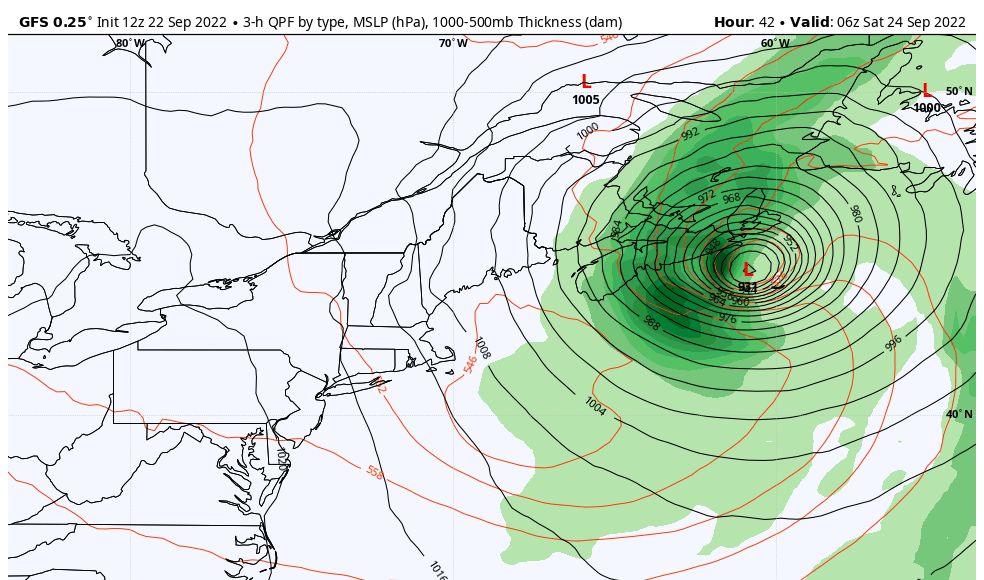
After sideswiping Bermuda, Fiona will accelerate northward, tugged a bit to the west by an approaching trough, or strip of low pressure, exiting the U.S. East Coast. That will send the storm careening into southeast Canada in eastern Nova Scotia or the Gulf of St. Lawrence.
Because the storm will be moving northward quickly, it won’t have much time to weaken, meaning it will still pack the punch of a Category 2 hurricane. It will possess a mix of tropical and high-latitude storm characteristics.
“We call this a deep hybrid low pressure system, possessing north tropical and intense winter storm properties with very heavy rainfall and severe winds,” wrote Environment Canada, the nation’s equivalent to the U.S. National Weather Service. “Most regions will experience some hurricane force winds. Similar cyclones of this nature have produced structural damage to buildings.”
Fiona grounded dozens of flights. A JetBlue plane flew right over the storm.
A storm of record strength and impact
Exacerbating the effect will be a “pressure dipole.” That means a sharp contrast in air pressure over a short distance, in this case owing to an intense high pressure dome southeast of Greenland. The steep gradient, or change in air pressure with distance, will funnel extremely strong winds toward the vacuum-like low.
The low pressure system itself could set an record for lowest air pressure anywhere in Canada. Models are simulating a storm with an air pressure between 930 and 935 millibars. The lowest barometric pressure ever observed in Canada was 940.2 millibars at St. Anthony in Newfoundland on Jan. 20, 1977. Typically, the lower the pressure, the stronger the storm.
The extreme air pressure gradient around Nova Scotia will result in wind gusts over 100 mph, fueling a storm surge of 5 to 8 feet, which will inundate the coasts with water and create hazardous conditions. On top of that, 4 to 6 inches of rain will generate additional risks.
Over the open ocean, wave heights may approach 80 feet, and there’s an outside chance that a few rogue waves could tower to near 100 feet. In early September 2019, the remnants of Hurricane Dorian appeared to have whipped up a 100-foot rogue wave near Port aux Basques, Newfoundland.
Brian Tang, an associate professor of atmospheric sciences at the University of Albany, tweeted that “Fiona will be [an] off the charts bad … generational storm for Nova Scotia.”
Fiona could even deliver some snow to portions of the Labrador Peninsula as the storm draws in very cold air on its northwest flank. Uninhabited regions of the empty Canadian tundra may pick up as much as 10 inches.


